YEAR 2026 (Jan - Dec) LONG DISTANCE TRAILS All-In-One Map Calendar
28 inches wide x 64 inches long
DIGITAL DOWNLOAD ONLY. (16MB PDF instant download following checkout - image is 300 dpi)
Looking to plan a long distance hike or two this year? Need to see a map and set a schedule for your hike, plan your training, and keep track of all the other parts of your life? This map and planner may be for you - featuring a grayscale map with 71 trails, a full year calendar, and plenty of space to take notes and mark dates and goals for your hiking plans and the rest of your life. You can write all over the map and calendar.
This all-in-one map calendar wall planner is designed to be printed to a 28" x 64" sheet size (i.e. perfect for the back of a door). This is a digital PDF file download, you are responsible for printing and associated printing costs.
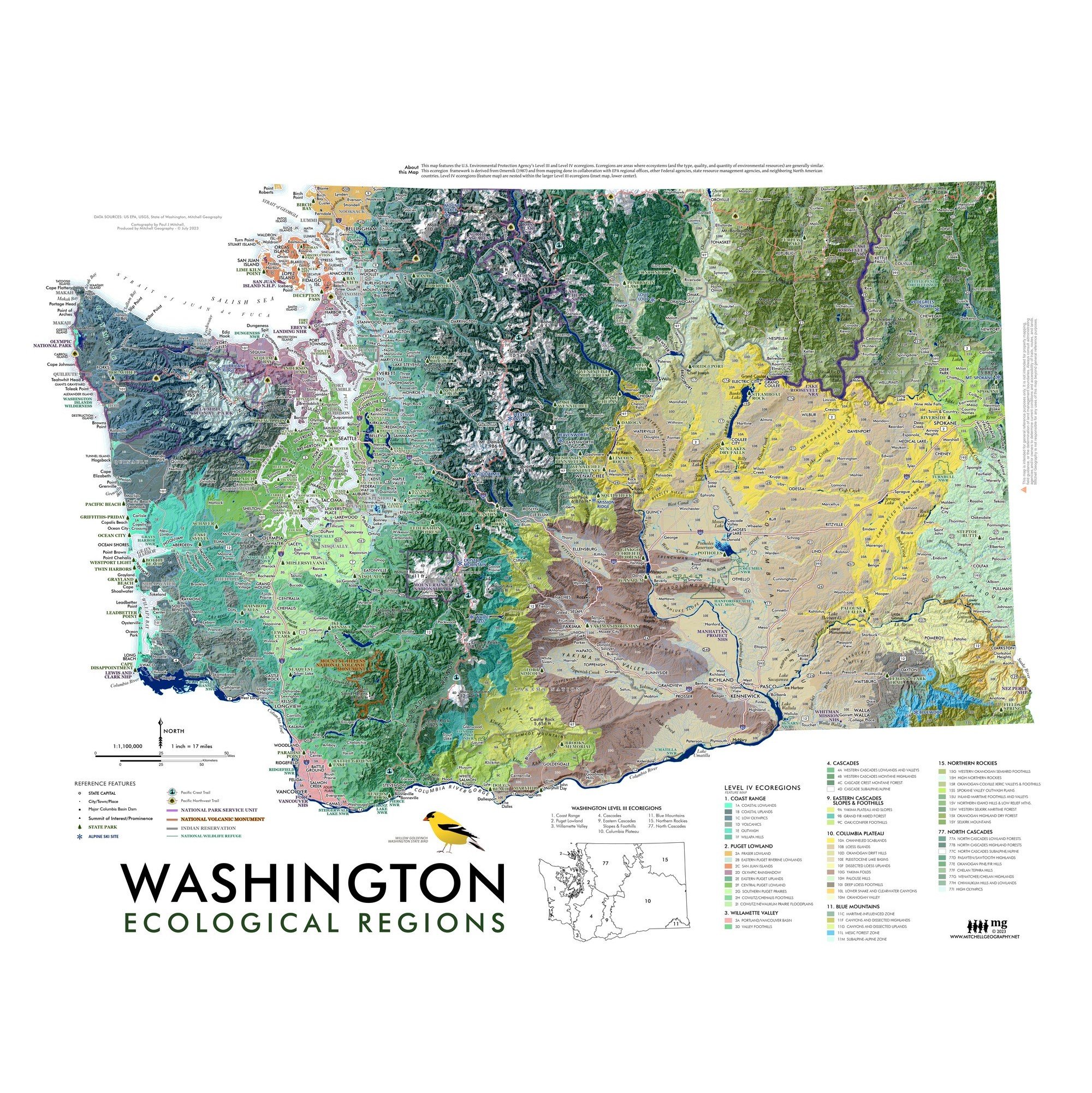
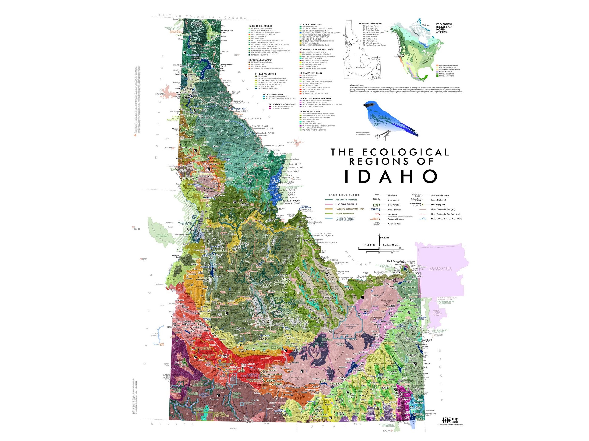
Featuring 71 long distance trails on a grayscale base-map at the top, you can draw and highlight travel plans directly on the map with colored pens/makers travel plans as well as make use of the full year weekend aligned calendar planner below. This map features the 48 conterminous states (Alaska & Hawaii aren't included sorry to say). Capsules for travel plans and goals, along with a fun state checklist allow you to keep track of trips and plans. A side bar for monthly note capsules gives you additional space to detail your plans.
Daily scheduling spaces are just over 1.5" x 1.5" squares. Official US Holidays are listed.
Map scale is 1:6,850,000
This national overview map of the conterminous lower 48 states features 71 long distance trails (included trails are listed below). This selection is intended to map the popular, proven, managed, and navigable trails that primarily require foot travel touching upon a journey or wilderness experience. The Triple Crown Trails (AT, CDT, PCT) are symbolized separately in red, while other trails are symbolized in orange. Places, interstate highways, national park units (scale dependent), hydrology, states, landforms, and significant regional high points are labeled for reference. The legend features trail miles and state locations of all the included trails.
Inspired by my 2005 Appalachian Trail, 2007 Newfoundland ECT, and 2011 Colorado Trail thru-hikes - I’d wanted to put all the trails I’ve continued to daydream about on one map (and without the historic NPS routes that aren’t really walkable, yet often appear on other similar national trail maps) along with an annual calendar planner. I also wanted to include some of the renowned shorter trails and loops that deliver a similar wilderness end-to-end experience yet without the serious time commitments (think of the Wonderland Trail, the Beaten Path, the Pemigewasset Loop, the Four Pass Loop, Eagle Rock Loop, Cactus to Clouds, etc). So this map features a balanced collection of these types of trails, as well as an attempt to map trails in each region of the lower 48 states.
There are a number of other proposed routes, new trails, and extensions to existing trails under development that with gained popularity perhaps can be included in a later edition. Some existing routes have also been excluded in cases of extensive gaps and connectivity issues (e.g. Bay Area Ridge Trail, Palmetto Trail, East Coast Greenway).
Included Trails:
TRIPLE CROWN
Appalachian Trail
Continental Divide Trail
Pacific Crest Trail
ADDITIONAL TRAILS
American Discovery Trail
Arizona Trail
Baker Trail
Bay Circuit Trail
Beaten Path, The
Benton MacKaye Trail
Black Creek Trail
Blue Mountains Trail
Boundary Trail (Washington)
Buckeye Trail
C&O Canal Trail
Cactus to Clouds
Centennial Trail (South Dakota)
Cohos Trail
Colorado Trail
Columbia Plateau (Washington)
Couer d'Alenes, Trail of the
Cowboy Trail
Cumberland Trail
Eagle Rock Loop
Empire State Trail
Finger Lakes Trail
Florida Trail
Foothills Trail
Four Pass Loop
George S. Mickelson Trail
Grafton Notch Loop
Grand Enchantment Trail
Great Allegheny Passage
Hayduke Trail
High Sierra Trail
Ice Age Trail
Idaho Centennial Trail
John Muir Trail
Katy Trail
Kettle Crest
Knobstone Trail
Lone Star Trail
Long Path
Long Trail
Lost Coast Trail
Maah Daah Hey Trail
Mountains to Sea
New England Trail
Northcountry Trail
Northville-Placid Trail
Oregon Coast Trail
Oregon Desert Trail
Ouachita Trail
Ozark Highlands Trail
Ozark Trail
Pacific Northwest Trail
Palouse to Cascades
Paul Bunyan State Trail
Pawnee Buchanan Loop
Pemigewasset Loop
Pinhoti Trail
Ruby Crest Trail
Sheltowee Trace
Superior Hiking Trail
Tahoe Rim Trail
Teton Crest Trail
Timberline Trail
Toyaibe Crest Trail
Trans-Catalina Trail
Uinta Highline Trail
Wapack Trail
Wonderland Trail
YEAR 2026 (Jan - Dec) LONG DISTANCE TRAILS All-In-One Map Calendar
28 inches wide x 64 inches long
DIGITAL DOWNLOAD ONLY. (16MB PDF instant download following checkout - image is 300 dpi)
Looking to plan a long distance hike or two this year? Need to see a map and set a schedule for your hike, plan your training, and keep track of all the other parts of your life? This map and planner may be for you - featuring a grayscale map with 71 trails, a full year calendar, and plenty of space to take notes and mark dates and goals for your hiking plans and the rest of your life. You can write all over the map and calendar.
This all-in-one map calendar wall planner is designed to be printed to a 28" x 64" sheet size (i.e. perfect for the back of a door). This is a digital PDF file download, you are responsible for printing and associated printing costs.
Featuring 71 long distance trails on a grayscale base-map at the top, you can draw and highlight travel plans directly on the map with colored pens/makers travel plans as well as make use of the full year weekend aligned calendar planner below. This map features the 48 conterminous states (Alaska & Hawaii aren't included sorry to say). Capsules for travel plans and goals, along with a fun state checklist allow you to keep track of trips and plans. A side bar for monthly note capsules gives you additional space to detail your plans.
Daily scheduling spaces are just over 1.5" x 1.5" squares. Official US Holidays are listed.
Map scale is 1:6,850,000
This national overview map of the conterminous lower 48 states features 71 long distance trails (included trails are listed below). This selection is intended to map the popular, proven, managed, and navigable trails that primarily require foot travel touching upon a journey or wilderness experience. The Triple Crown Trails (AT, CDT, PCT) are symbolized separately in red, while other trails are symbolized in orange. Places, interstate highways, national park units (scale dependent), hydrology, states, landforms, and significant regional high points are labeled for reference. The legend features trail miles and state locations of all the included trails.
Inspired by my 2005 Appalachian Trail, 2007 Newfoundland ECT, and 2011 Colorado Trail thru-hikes - I’d wanted to put all the trails I’ve continued to daydream about on one map (and without the historic NPS routes that aren’t really walkable, yet often appear on other similar national trail maps) along with an annual calendar planner. I also wanted to include some of the renowned shorter trails and loops that deliver a similar wilderness end-to-end experience yet without the serious time commitments (think of the Wonderland Trail, the Beaten Path, the Pemigewasset Loop, the Four Pass Loop, Eagle Rock Loop, Cactus to Clouds, etc). So this map features a balanced collection of these types of trails, as well as an attempt to map trails in each region of the lower 48 states.
There are a number of other proposed routes, new trails, and extensions to existing trails under development that with gained popularity perhaps can be included in a later edition. Some existing routes have also been excluded in cases of extensive gaps and connectivity issues (e.g. Bay Area Ridge Trail, Palmetto Trail, East Coast Greenway).
Included Trails:
TRIPLE CROWN
Appalachian Trail
Continental Divide Trail
Pacific Crest Trail
ADDITIONAL TRAILS
American Discovery Trail
Arizona Trail
Baker Trail
Bay Circuit Trail
Beaten Path, The
Benton MacKaye Trail
Black Creek Trail
Blue Mountains Trail
Boundary Trail (Washington)
Buckeye Trail
C&O Canal Trail
Cactus to Clouds
Centennial Trail (South Dakota)
Cohos Trail
Colorado Trail
Columbia Plateau (Washington)
Couer d'Alenes, Trail of the
Cowboy Trail
Cumberland Trail
Eagle Rock Loop
Empire State Trail
Finger Lakes Trail
Florida Trail
Foothills Trail
Four Pass Loop
George S. Mickelson Trail
Grafton Notch Loop
Grand Enchantment Trail
Great Allegheny Passage
Hayduke Trail
High Sierra Trail
Ice Age Trail
Idaho Centennial Trail
John Muir Trail
Katy Trail
Kettle Crest
Knobstone Trail
Lone Star Trail
Long Path
Long Trail
Lost Coast Trail
Maah Daah Hey Trail
Mountains to Sea
New England Trail
Northcountry Trail
Northville-Placid Trail
Oregon Coast Trail
Oregon Desert Trail
Ouachita Trail
Ozark Highlands Trail
Ozark Trail
Pacific Northwest Trail
Palouse to Cascades
Paul Bunyan State Trail
Pawnee Buchanan Loop
Pemigewasset Loop
Pinhoti Trail
Ruby Crest Trail
Sheltowee Trace
Superior Hiking Trail
Tahoe Rim Trail
Teton Crest Trail
Timberline Trail
Toyaibe Crest Trail
Trans-Catalina Trail
Uinta Highline Trail
Wapack Trail
Wonderland Trail

 Image 1 of 12
 Image 2 of 12
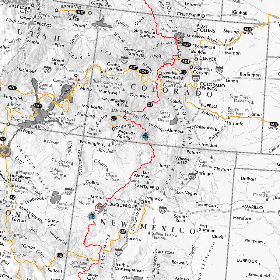 Image 3 of 12
 Image 4 of 12
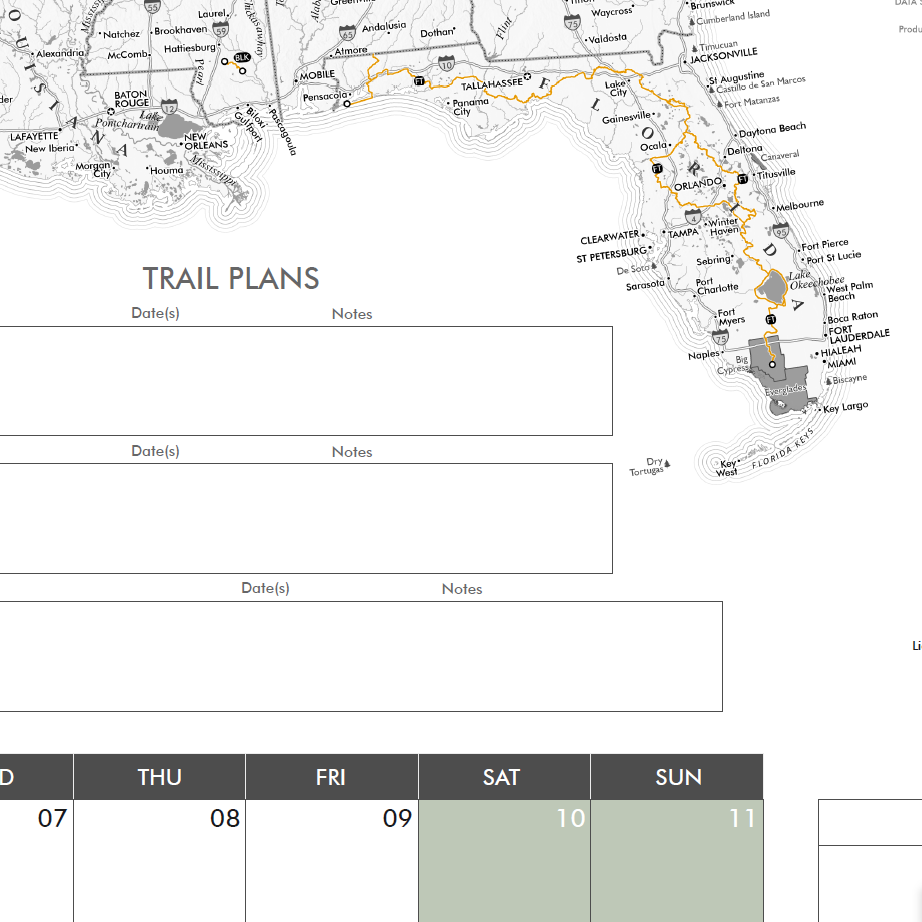 Image 5 of 12
 Image 6 of 12
 Image 7 of 12
 Image 8 of 12
 Image 9 of 12
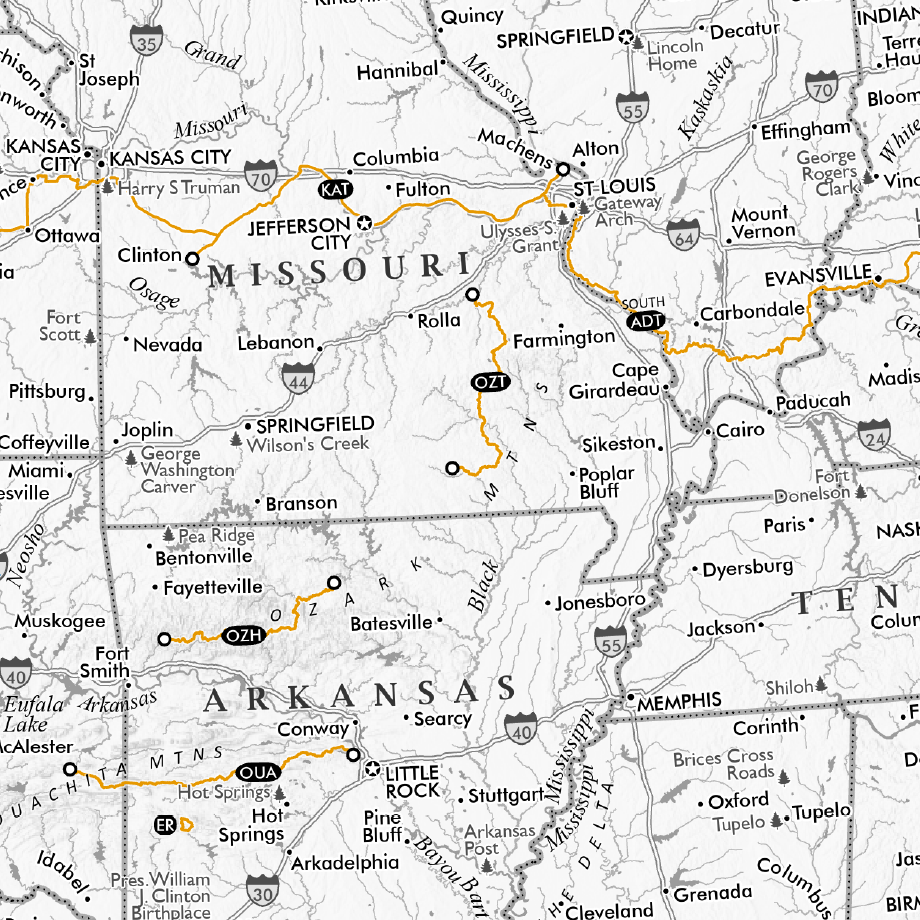 Image 10 of 12
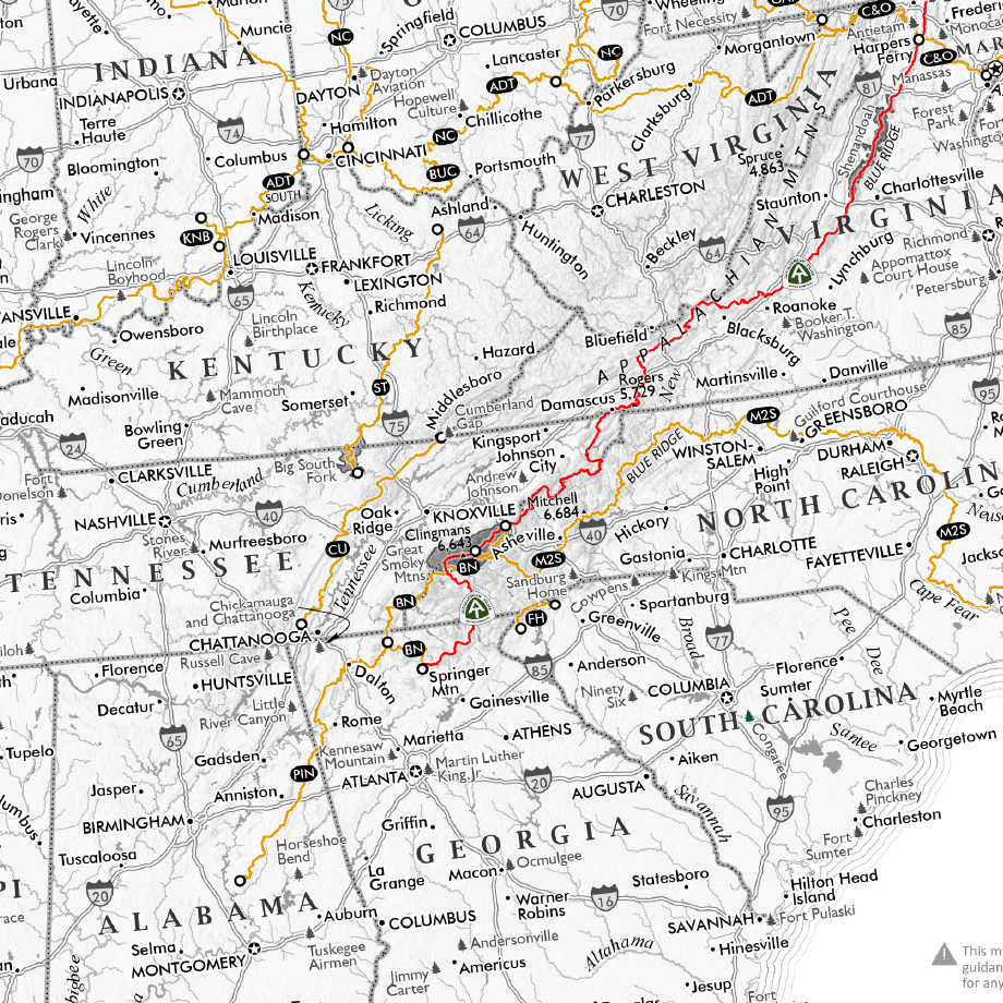 Image 11 of 12
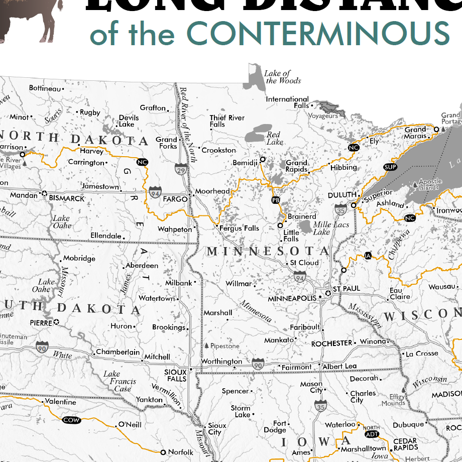 Image 12 of 12