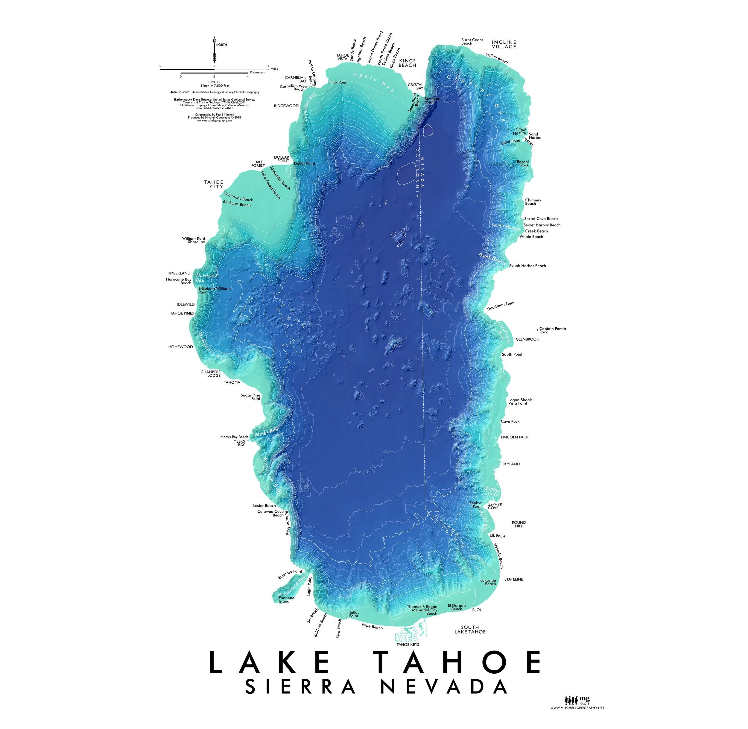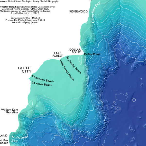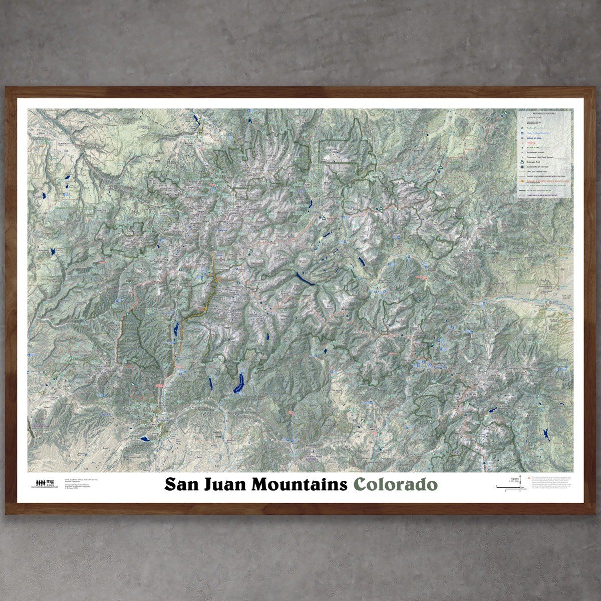


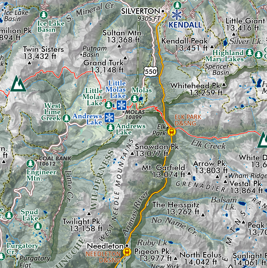


San Juan Mountains - Colorado (28 in x 20 in)
1:275,000
28 inch x 20 inch — flat wall map, printed on a heavy fine paper — ships rolled.
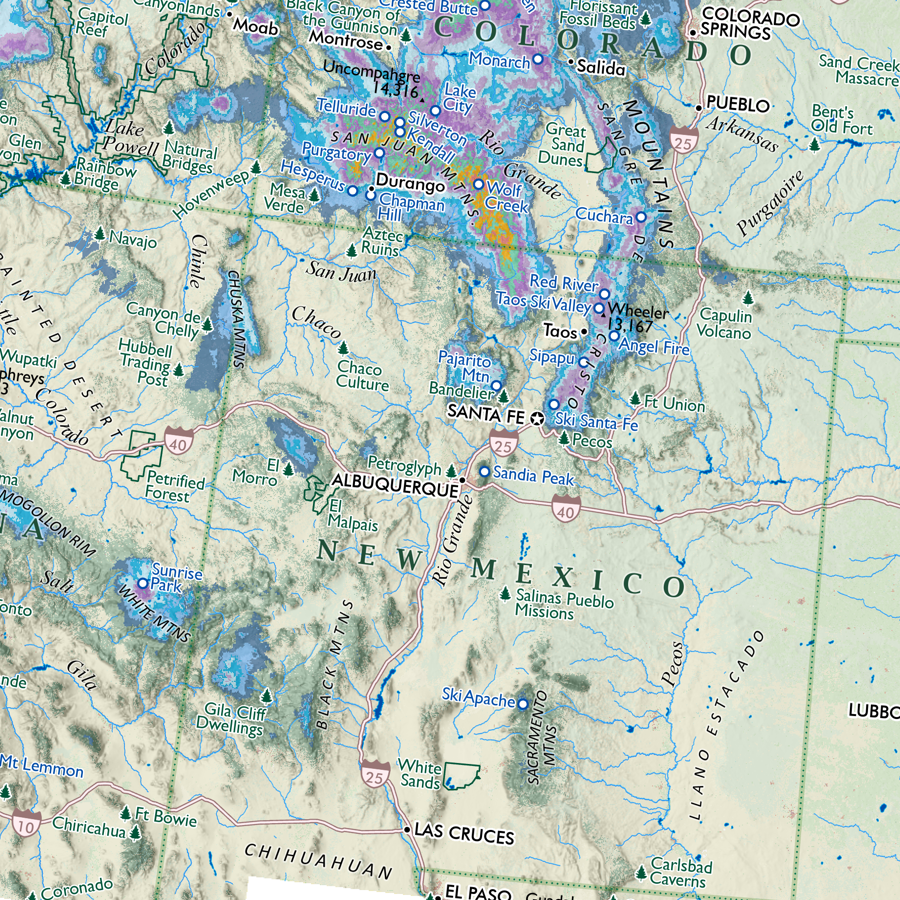
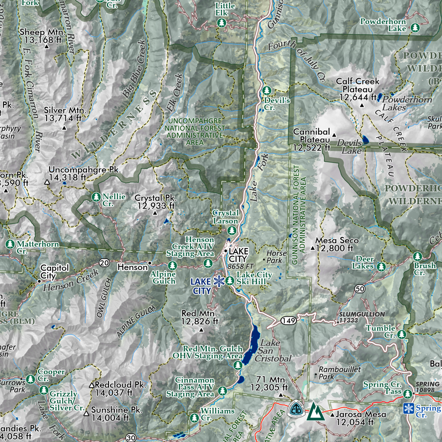
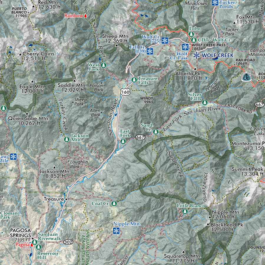
San Juan Mountains, Colorado. This is a regional overview and general reference styled map, centered upon the core of the San Juan Mountains in southwest Colorado. Packed with details considering it’s scale and sheet size - you will need excellent map reading skills and some familiarity with the region to fully enjoy the fine print, small typefaces, and occasional dense labeling.
The map features:
City/town/locale place names
Trails
Colorado Trail & Continental Divide Trail (with unique symbolization)
Notable Passes with elevations
Summits and high points (fourteeners have unique symbolization)
Hot springs
Alpine ski areas
Trailhead/access sites
Winter Trailhead/access sites
Notable Alpine Basins
Topographic Features
National Forest Administrative Area Boundaries
Federal Wilderness Boundaries
National Park/Monument Features
Durango & Silverton Narrow Gauge Railroad (with Needleton and Elk Park wilderness stops mapped)
Locales within map extent: Ridgway, Ouray, Telluride, Ophir, Rico, Silverton, Mancos, Durango, Bayfield, Pagosa Springs, South Fork, Del Norte, Creede, Lake City
Due to the scale and sheet size, highways and major roads are labeled with highway/county/local/forest service route numbers (i.e. not by name). Backcountry gravel roads and road based OHV/double track trails are not labeled — they are mapped to infer geographic reference. Again this is a general reference and overview wall map — for detailed trip planning you will want to confer additional sources specific to your destination. Please consult landowners and administrating agencies to clarify current accessibility of trails, roads, routes, and lands as well as any seasonal restrictions.
Centered upon the core of the San Juans, i.e. the Weminuche Wilderness and areas north of Durango and Pagosa Springs up to Ridgway — while most of the Southern San Juans are also mapped, a small area south of the Chalk Mountains sub-range is cut-off the bottom of the sheet (e.g. Chromo is not on the map).
Mitchell Geography is not responsible for any uses of this map beyond general reference purposes.
1:275,000
28 inch x 20 inch — flat wall map, printed on a heavy fine paper — ships rolled.
San Juan Mountains, Colorado. This is a regional overview and general reference styled map, centered upon the core of the San Juan Mountains in southwest Colorado. Packed with details considering it’s scale and sheet size - you will need excellent map reading skills and some familiarity with the region to fully enjoy the fine print, small typefaces, and occasional dense labeling.
The map features:
City/town/locale place names
Trails
Colorado Trail & Continental Divide Trail (with unique symbolization)
Notable Passes with elevations
Summits and high points (fourteeners have unique symbolization)
Hot springs
Alpine ski areas
Trailhead/access sites
Winter Trailhead/access sites
Notable Alpine Basins
Topographic Features
National Forest Administrative Area Boundaries
Federal Wilderness Boundaries
National Park/Monument Features
Durango & Silverton Narrow Gauge Railroad (with Needleton and Elk Park wilderness stops mapped)
Locales within map extent: Ridgway, Ouray, Telluride, Ophir, Rico, Silverton, Mancos, Durango, Bayfield, Pagosa Springs, South Fork, Del Norte, Creede, Lake City
Due to the scale and sheet size, highways and major roads are labeled with highway/county/local/forest service route numbers (i.e. not by name). Backcountry gravel roads and road based OHV/double track trails are not labeled — they are mapped to infer geographic reference. Again this is a general reference and overview wall map — for detailed trip planning you will want to confer additional sources specific to your destination. Please consult landowners and administrating agencies to clarify current accessibility of trails, roads, routes, and lands as well as any seasonal restrictions.
Centered upon the core of the San Juans, i.e. the Weminuche Wilderness and areas north of Durango and Pagosa Springs up to Ridgway — while most of the Southern San Juans are also mapped, a small area south of the Chalk Mountains sub-range is cut-off the bottom of the sheet (e.g. Chromo is not on the map).
Mitchell Geography is not responsible for any uses of this map beyond general reference purposes.